"The Everitt House" stood on the river side of Old Mine Road, south of Montague, NJ, and just north of the Sandyston line. This house was photographed and documented by the Historical American Buildings Survey (HABS) shortly before it was demolished for the Tocks Island project in 1975. I believe that several generations of my Everitt ancestors lived in this house. A family cemetery on the property still exists.
I believe this to be where Isaac Everitt (1771 - 1833) lived. His son Allen (1814 - 1894) bought out the other heirs, but later sold the house to his nephew, Daniel Davis Everitt (son of John D. E.), my great-grandfather. After Daniel, I believe that it was occupied by my grandfather, Harry Creveling Everitt. I think it is likely that my father and my aunt were born in this house. It was sold out of the family circa 1919, when my grandmother, Maggie Bevans Everitt (1871 - 1949) brought the family to Stroudsburg (my grandfather having died in 1907).
Click this link to view the HABS record (including photos) through the Library of Congress web site: HABS Record
Click here to view a map (requires Acrobat) of the property, as sold in 1919. This map as made using traverse data on a surveyor's map that was kindly provided to me by Jack Decker, assistant historian at M.A.R.C.H. The property consisted of four tracts, the largest of which straddled Old Mine Road at the S-curve, about 2 miles south of the Brick House in Montague. The other tracts were on the southern tips of Minisink Island and an adjoining Island on its east side, as well as the entire area of another small island on the west side of Minisink Island. The total area of the four tracts was just under 200 acres. All of this land is now part of the Delaware Water Gap National Recreation Area.
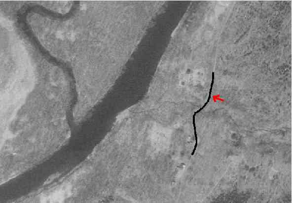
Some traces of the farm are visible in this aerial infrared photo taken on April 15, 1992. I have sketched in the S-curve on Old Mine Road as a thick black line. The Everitt house was located at about the position of the red arrow, but across the road. A stone wall, which is still standing (but now very overgrown) is just visible as a dark oblong blob next to the road. A stream that runs through a steep ravine is clearly visible just to the south of where the house stood. Also visible are some tall trees, and some relatively clear areas that may have been where outbuildings were bulldozed.
I visited the site in July, 2001, and was guided to the family burial plot by Alicia Batko and Jack Decker of M.A.R.C.H. There are several fieldstone markers in a plot of roughly one-quarter acre located in a beautiful shaded spot on top of the river bank.

Alicia Batko and Jack Decker leading the way to the cemetery. Two stone grave markers are visible on the edge of the river bank to Jack's left.
Most of the stones have no legible markings. Alicia knows of a deed whereby this property was set aside for use as a burial plot, and which mentioned the grave of Isaac Everitt as being in the center of the plot. The burial plot is now in poor condition. Many of the stones are broken or scattered.
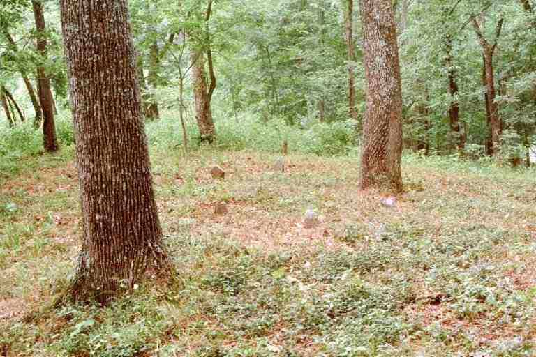
Several stone markers are visible in this view facing northerly. The river is to the left. A ravine, straight ahead, forms the edge of the burial plot.
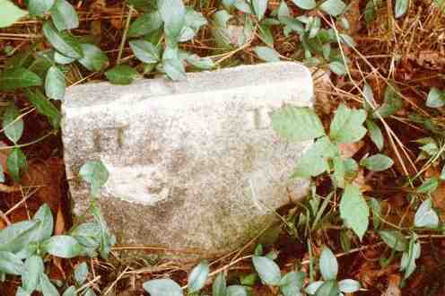
One broken stone has the initials "C A B". carved in large letters. This is probably not a grave marker. According to Alicia, "The C.A.B. is believed to be a stone carved for a former owner - Charles A. Brace, which was moved away from the house when it was demolished and ended up near the burial ground, so it was set up as found there."
Another stone, seen below, bears the initials "H D". Might this be Hannah Everitt Depue (1809 - 1840), daughter of Isaac Everitt and Mary Davis, and wife of Elisha Depue?
I am grateful for the efforts of Alicia Batko and her colleagues at M.A.R.C.H., who have greatly aided my research. Alicia and Bob Longcore found the Everitt burial ground. According to Alicia, Mr. Longcore "has long been dedicated to clearing old family plats and cemeteries with the aid of Sussex County Sheriff's office SWAP and SLAP teams. They are the ones who have done the labor under his direction...".